


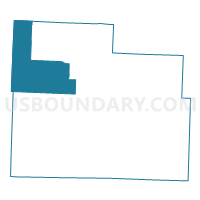
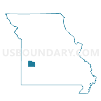
Box No. 2 Voting District, Cedar County, Missouri
About
Outline

Summary
| Unique Area Identifier | 607451 |
| Name | Box No. 2 Voting District |
| County | Cedar County |
| State | Missouri |
| Area (square miles) | 51.96 |
| Land Area (square miles) | 51.66 |
| Water Area (square miles) | 0.30 |
| % of Land Area | 99.42 |
| % of Water Area | 0.58 |
| Latitude of the Internal Point | 37.80904370 |
| Longtitude of the Internal Point | -94.00014930 |
Maps

Graphs
Select a template below for downloading or customizing gragh for Box No. 2 Voting District, Cedar County, Missouri


Neighbors
Neighoring Voting District (by Name) Neighboring Voting District on the Map
- Benton Voting District, Cedar County, MO
- Box No. 1 Voting District, Cedar County, MO
- Cedar Voting District, Cedar County, MO
- Harwood Town Hall Voting District, Vernon County, MO
- North Linn Voting District, Cedar County, MO
- Sheldon Community Building Voting District, Vernon County, MO
- Speedwell Voting District, St. Clair County, MO
- Virgil Voting District, Vernon County, MO
Top 10 Neighboring County Subdivision (by Population) Neighboring County Subdivision on the Map
- Box township, Cedar County, MO (5,814)
- Linn township, Cedar County, MO (3,880)
- Benton township, Cedar County, MO (1,087)
- Clear Creek township, Vernon County, MO (645)
- Speedwell township, St. Clair County, MO (511)
- Cedar township, Cedar County, MO (488)
- Virgil township, Vernon County, MO (443)
- Montevallo township, Vernon County, MO (318)
Top 10 Neighboring Place (by Population) Neighboring Place on the Map
Top 10 Neighboring Unified School District (by Population) Neighboring Unified School District on the Map
Top 10 Neighboring State Legislative District Lower Chamber (by Population) Neighboring State Legislative District Lower Chamber on the Map
- State House District 133, MO (37,830)
- State House District 119, MO (36,209)
- State House District 125, MO (35,564)
Top 10 Neighboring State Legislative District Upper Chamber (by Population) Neighboring State Legislative District Upper Chamber on the Map
Top 10 Neighboring 111th Congressional District (by Population) Neighboring 111th Congressional District on the Map
Top 10 Neighboring Census Tract (by Population) Neighboring Census Tract on the Map
- Census Tract 8701, Cedar County, MO (5,661)
- Census Tract 8702, Cedar County, MO (5,002)
- Census Tract 9501, Vernon County, MO (3,422)
- Census Tract 9506, Vernon County, MO (3,092)
- Census Tract 4802, St. Clair County, MO (2,952)